
Exploring the Earth: The Power of Earth Observation
Introduction
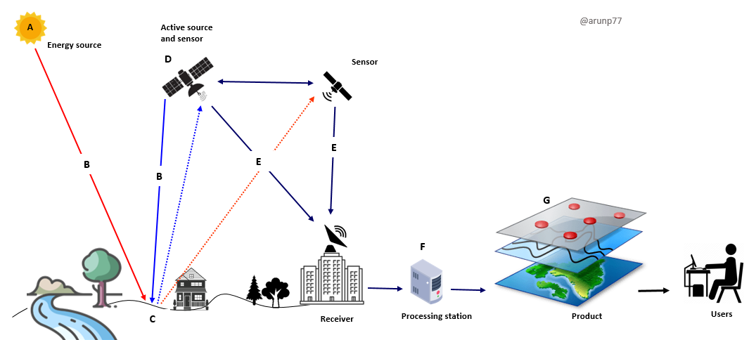
Earth observation, the systematic monitoring of the Earth's surface, atmosphere, and oceans, has revolutionized our understanding of the planet. From tracking climate change to monitoring natural disasters, Earth observation plays a pivotal role in various fields, including environmental science, agriculture, urban planning, and disaster management.History of Earth Observation
Earth observation has a rich history, dating back to ancient civilizations' observations of the sky and the land. However, modern Earth observation techniques began to emerge in the mid-20th century with the launch of satellites and the development of remote sensing technologies. The launch of NASA's Landsat program in 1972 marked a significant milestone, providing the first continuous global record of the Earth's surface.Technologies in Earth Observation
- Remote Sensing : Remote sensing refers to the process of gathering information about objects or areas from a distance, typically without direct physical contact. It encompasses various techniques, including satellite imaging, aerial photography, and ground-based sensors. Remote sensing can utilize different platforms and sensors to collect data across the electromagnetic spectrum. Remote sensing techniques, including LiDAR (Light Detection and Ranging) and RADAR (Radio Detection and Ranging), enable scientists to measure various environmental parameters, such as topography, soil moisture, and atmospheric composition.
- Satellite Imaging: Satellite imaging is a specific application of remote sensing that involves capturing images of the Earth's surface using sensors mounted on satellites orbiting the Earth. Satellites equipped with advanced sensors capture high-resolution images of the Earth's surface. These images provide valuable information about land cover, land use, vegetation health, and urban development. Satellite imaging with advanced sensors involves a complex process that combines cutting-edge technology with precise engineering. Here's an overview of how satellite imaging and advanced sensors capture images:
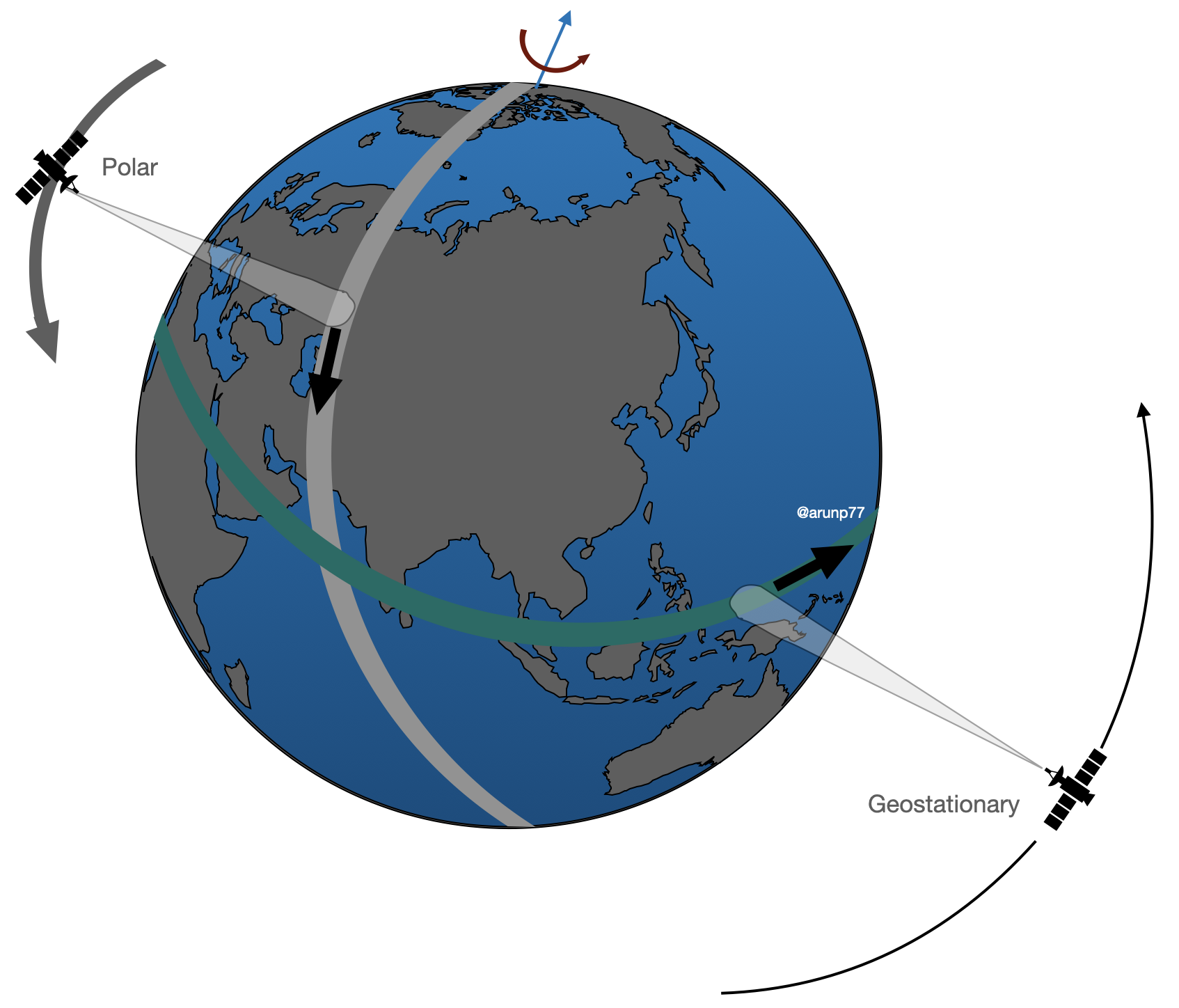
- Satellite Orbits: Satellites orbit the Earth in various configurations, including:
- polar orbits,
- geostationary orbits, and
- sun-synchronous orbits.
- Sensor Systems: Satellites are equipped with sophisticated sensor systems designed to capture images of the Earth's surface. These sensor systems may include
- optical sensors,
- multispectral sensors,
- hyperspectral sensors,
- thermal infrared sensors, and
- synthetic aperture radar (SAR) systems.
- Satellite Orbits: Satellites orbit the Earth in various configurations, including:
- Aerial Photography: Aerial photography, conducted using aircraft or drones, offers detailed imagery for mapping, land surveying, and environmental monitoring applications.
- GIS (Geographic Information Systems): GIS technology enables the integration, analysis, and visualization of spatial data collected through Earth observation techniques. It helps researchers and policymakers make informed decisions about resource management, infrastructure planning, and disaster response.
Earth Satellite Orbits
Earth satellites, these artificial celestial bodies, dance around our planet in various orbits, each with its own unique purpose and characteristics. These orbits are determined by factors such as altitude, inclination, and eccentricity. Earth orbits can be devided into following three main categories: (for more details, please checkout Types of orbits).Credit: Authors of the creator of the video.
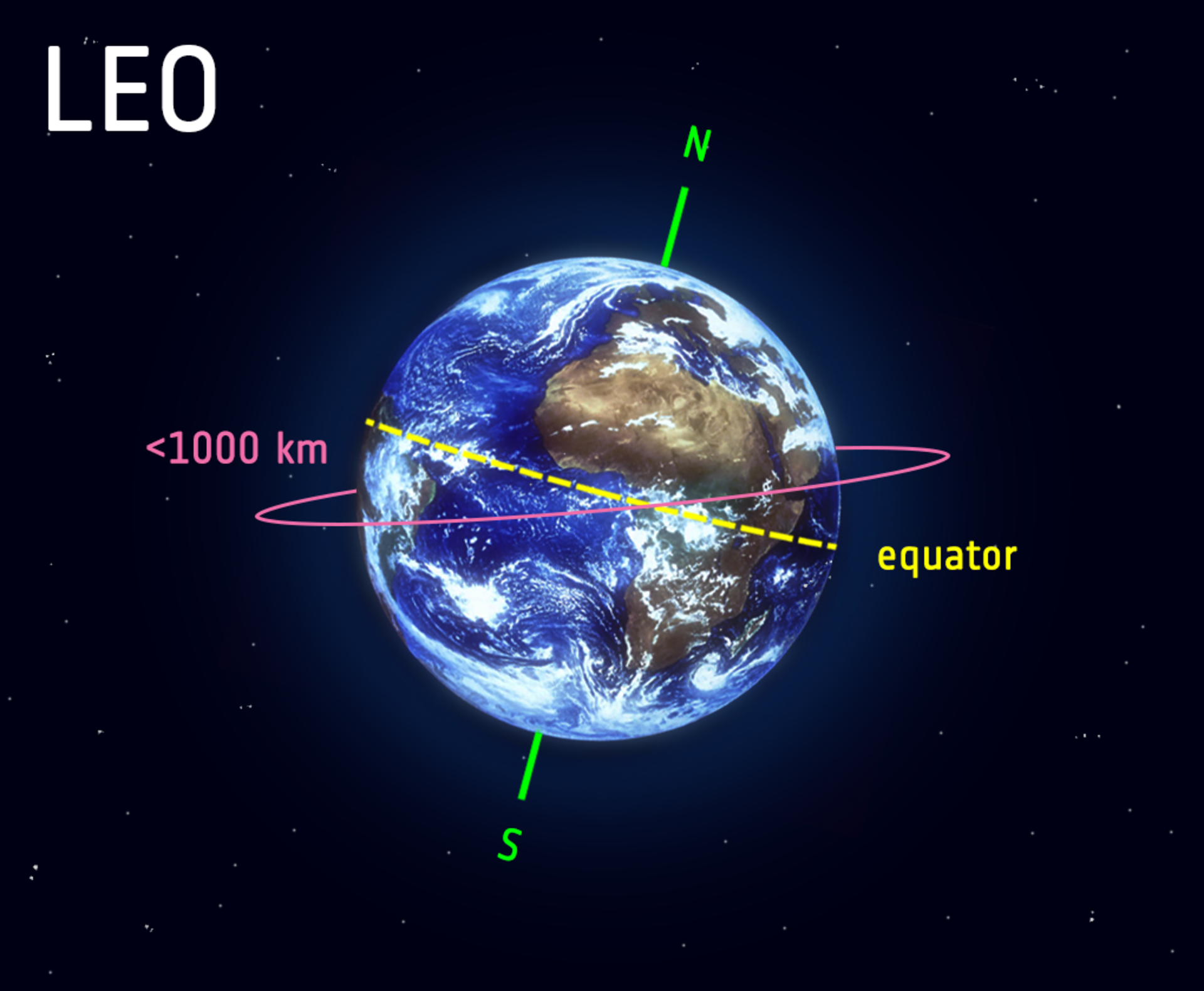
- Low Earth Orbit (LEO):
- Altitude: Approximately 160-2,000 kilometers above Earth's surface
- Purpose: Earth observation, scientific research, communications, and space stations. LEO satellites offer advantages for remote sensing, providing high-resolution imagery and frequent revisits due to their shorter orbital periods.
- Characteristics: Short orbital periods (around 90 minutes), frequent passes over the same region, and low atmospheric drag.
- Examples of LEO remote sensing satellites include the Landsat series and the International Space Station (ISS).
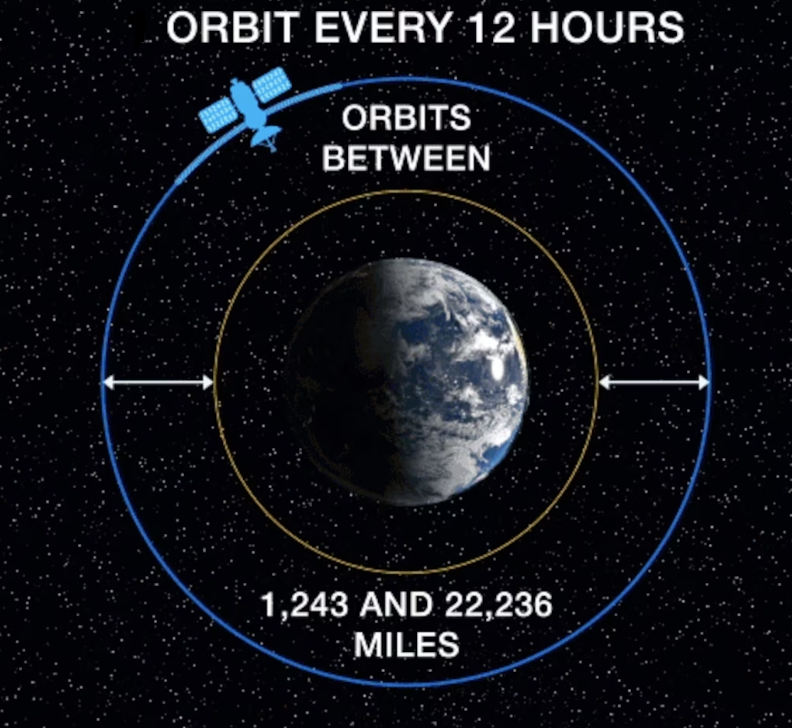
Credit: ESA–L. Boldt-Christmas (ESA Standard Licence) - Medium Earth Orbit (MEO):
- Altitude: Approximately 2,000-35,786 kilometers above Earth's surface.
- Purpose: Global navigation satellite systems (GNSS) like GPS, GLONASS, Galileo, and BeiDou/ These orbits provide a balance between coverage and resolution, making them suitable for a variety of applications, including navigation systems like GPS.
- Characteristics: Orbital periods of around 12 hours, suitable for providing continuous coverage over large areas.
- Examples of MEO satellites include those in the Global Navigation Satellite System (GNSS) constellations.
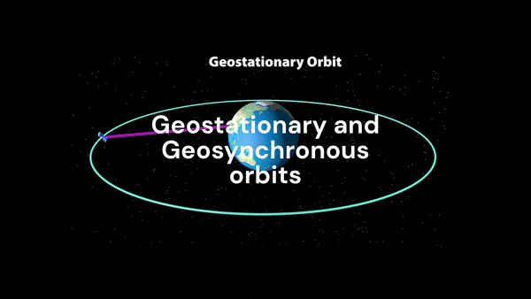
Credit: Lisa Sodders, SSC Public Affairs. - Geostationary Orbit (GEO):
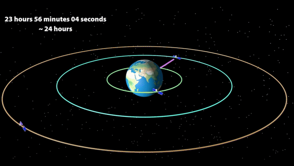
- Altitude: Approximately 35,786 kilometers above Earth's surface
- Purpose: Communications, weather forecasting, and broadcasting.
- Characteristics: Orbital period of 24 hours, appears stationary from Earth's surface, ideal for providing continuous coverage over a specific region. These satellites provide continuous coverage of a specific region, making them ideal for applications like weather monitoring and communication.
- Examples include weather satellites like GOES (Geostationary Operational Environmental Satellite).
Credit: Authors of the creator of the video. 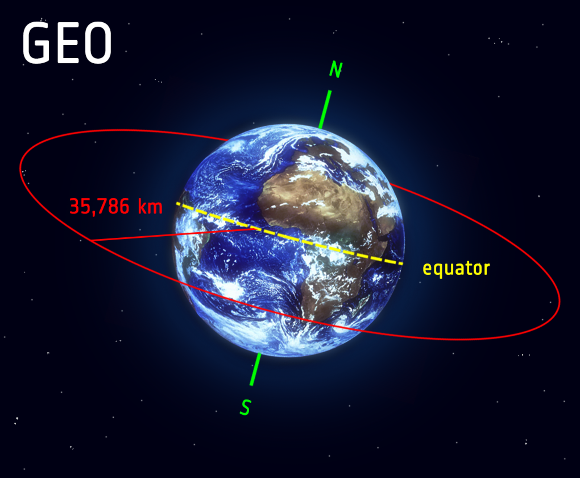
Credit: ESA – L. Boldt-Christmas (ESA Standard Licence). - Polar Orbit:
- Satellites in polar orbits pass over Earth's poles, providing global coverage with each orbit.
- These orbits are well-suited for Earth observation missions, as they cover the entire surface over time.
- Examples include satellites from the Copernicus program, such as Sentinel-1 and Sentinel-2 (see the Official website).
We can also devide the earth orbits as follows:
- Polar orbit and Sun-synchronous orbit (SSO): Satellites in polar orbits usually travel past Earth from north to south rather than from west to east, passing roughly over Earth's poles.
- Polar orbits:
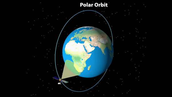
Credit: Authors of the creator of the video. - Inclination: Approximately 90 degrees to the equator.
- Purpose: Earth observation, remote sensing, and scientific research
- Height: Polar orbits are a type of low Earth orbit, as they are at low altitudes between 200 to 1000 km.
- Characteristics: Passes over both poles of Earth, provides global coverage, and is often used for weather forecasting and environmental monitoring.
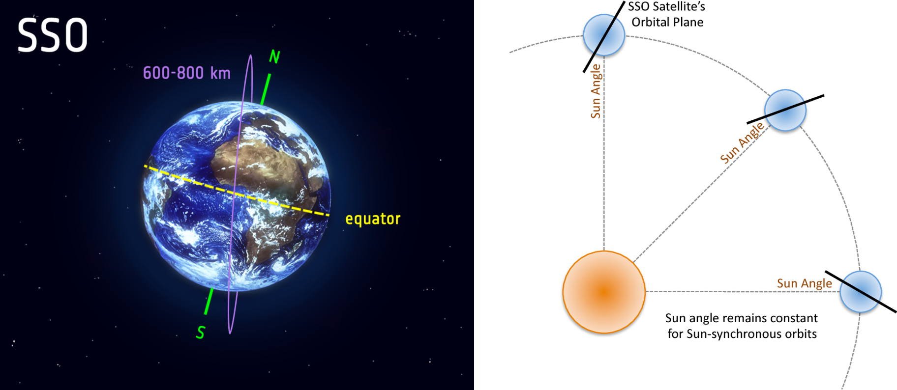
- Sun-synchronous orbit (SSO): Sun-synchronous orbits (SSOs) are a specific type of polar orbit where satellites pass over the Earth's poles while maintaining a constant position relative to the Sun. This means that a satellite in SSO always observes a particular location on Earth at the same local time, allowing for consistent comparisons over time. To ensure continuous sunlight, SSO satellites often orbit at dawn or dusk. This avoids shadows cast by the Earth and allows for uninterrupted observations. The typical altitude for SSO satellites is between 600 and 800 kilometers, and at 800 kilometers, they travel at approximately 7.5 kilometers per second.
- Inclination: Approximately 97-99 degrees to the equator
- Purpose: Earth observation, remote sensing, and scientific research
- Characteristics: Passes over the same point on Earth at the same local time each day, ideal for studying seasonal variations and long-term trends.
Credit: ESA – L. Boldt-Christmas (ESA Standard Licence). 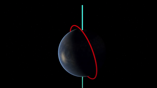
Credit: EUMESAT. - Polar orbits:
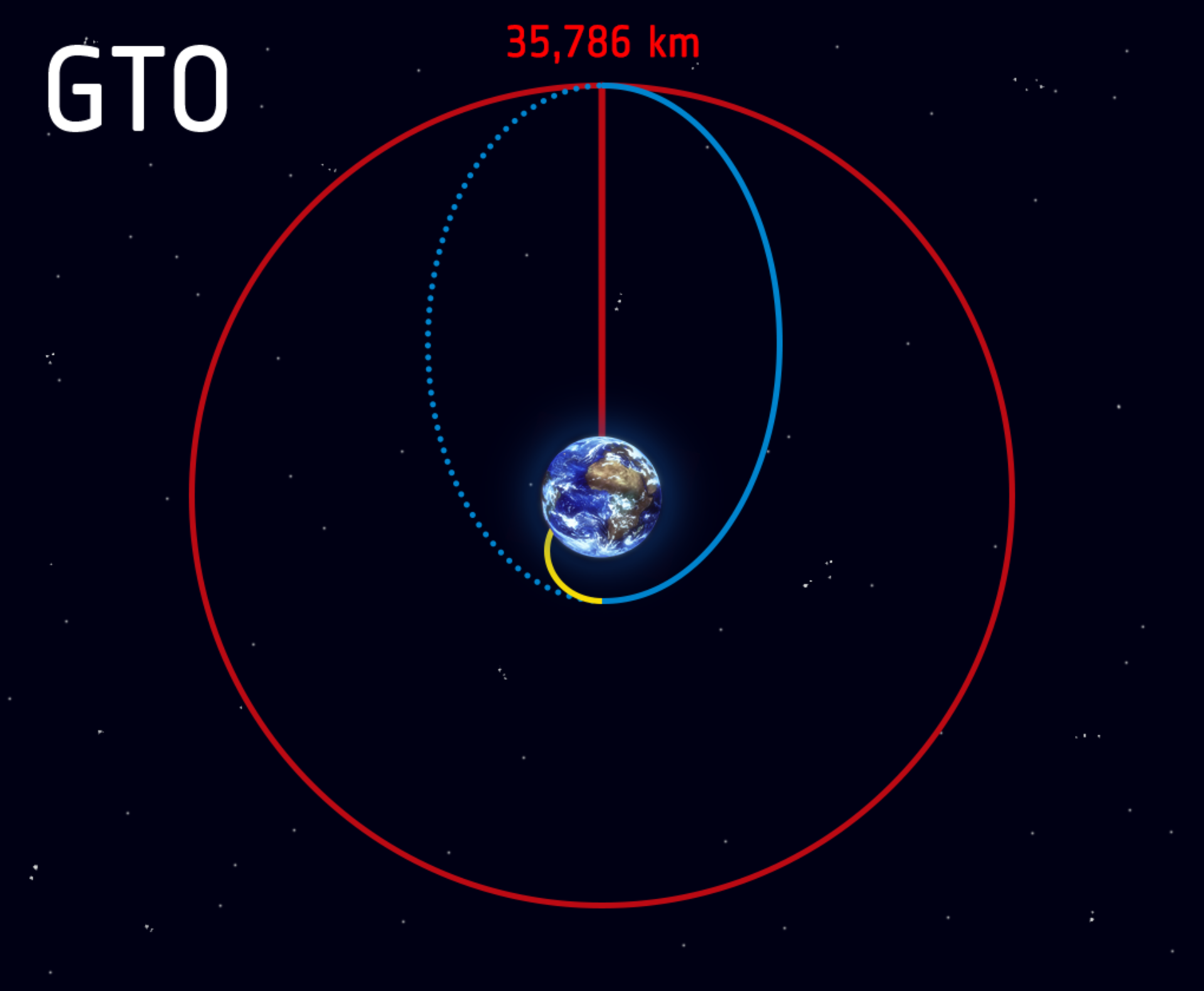
- Transfer orbits: Transfer orbits are used to transport spacecraft from one orbit to another. They typically involve a series of maneuvers that change the spacecraft's velocity and altitude to achieve the desired orbit.
- Geostationary transfer orbit (GTO): Geostationary transfer orbit (GTO) is a specific type of transfer orbit used to transport satellites from low Earth orbit (LEO) to geosynchronous orbit (GEO). A GEO is a circular orbit with an altitude of approximately 35,786 kilometers above the Earth's equator. Satellites in this orbit appear to be stationary from the Earth's surface, making them ideal for communications, broadcasting, and weather monitoring.
Credit: ESA – L. Boldt-Christmas (ESA Standard Licence). - Molniya Orbit: Highly elliptical orbit used for communications in high-latitude regions.
- Tundra Orbit: Similar to Molniya orbit but with a higher apogee.
References
- My github Repositories on Remote sensing fundamentals..
- Low Earth orbit (LEO)
- Geostationary orbit (GEO)
- Medium Earth orbit (MEO)
- Polar and Sun-synchronous orbit
- Transfer orbits and geostationary transfer orbit (GTO)
- Lagrange points
- Geostationary transfer orbit (GTO)
- High latitude simulator for MTG FCI instrument
Some other interesting things to know:
- Visit my website on For Data, Big Data, Data-modeling, Datawarehouse, SQL, cloud-compute.
- Visit my website on Data engineering