
Climate Data

International initiatives for the climate monitoring
The space-based architecture for climate monitoring is a major international framework for space agencies to respond to the needs of systematic observation of the Earth's climate system. These needs are mostly defined through the United Nations Framework Convention on Climate Change (UNFCCC) and are facilitated by the Global Climate Observing System (GCOS). GCOS is a partnership of international organizations, scientific institutions, and governments that is responsible for ensuring that the world has the essential climate data and information needed for climate-related decision-making. GCOS formulates specific needs and requirements towards the space sector to ensure that space missions are designed and implemented to provide the data needed for climate monitoring and research.Space agencies coordinate their response to these needs via the Coordination Group of Meteorological Satellites (CGMS) and the Committee for Earth Observation Satellites (CEOS) that jointly established the CEOS/CGMS Working Group on Climate (WGClimate). This joint working group implements the Architecture for Monitoring Climate from Space and has been assigned three overarching objectives:
- Providing a comprehensive and accessible view of existing and planned climate data records
- Delivering further climate data records, including multi-mission, through best use of available data.
- Optimise the planning of future satellite missions and constellations to expand existing and planned climate data records.
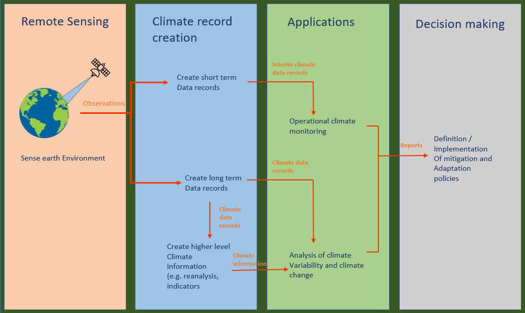
The first goal is about creating a list of climate data records that focus on Essential Climate Variables (ECVs) as defined by the Global Climate Observing System (GCOS). This list is called the ECV inventory.
Specific gap analyses based on the ECV Inventory and a coordinated action plan address the second and third objectives of the joint working group.
Fundamental Climate Data Records (FCDRs) and Essential Climate Variables (ECVs)
Climate data record is a specific definition developed by the CEOS-CGMS Joint Working Group on Climate in 2020. The group defines three types of climate data records (For more details, see following: Reference).- Fundamental Climate Data Records (FCDRs) (or a level-1 data): A Fundamental Climate Data Record (FCDR) is a well-characterised, long-term data record, usually involving a series of instruments, with potentially changing measurement approaches, but with overlaps and calibrations sufficient to allow the generation of products that are accurate and stable, in both space and time, to support climate applications. FCDRs are typically calibrated radiances, backscatter of active instruments, or radio occultation bending angles. FCDRs also include the ancillary data used to calibrate them. The term FCDR has been adopted by GCOS and can be considered as an international consensus definition. (Example).
- Thematic Climate Data Records (TCDRs) (or level-2-3 data): A Thematic Climate Data Record (TCDR) is the counterpart of the FCDR in geophysical space. TCDRs that consists of a consistently processed time series of uncertainty-quantified retrieved values of a geophysical variable or related indicator, located in time and space, and of sufficient length and quality to be useful for climate science or applications (Example)
- Interim Climate Data Records (ICDRs): ICDRs that are consistently processed times series of uncertainty-quantified estimates of CDR values produced with better timeliness than, but otherwise minimizing differences with, the estimated CDR values. ICDRs are important to monitor climate closer to real time and actual developments of sea ice concentrations are a good example for that.
Lets study important terminologies one by one. We will consider CDR first and then breifly see how it is different from the Essential Climate Variables (ECVs).
1. Climate data Record (CDR)
So the climate data record (CDR) is a long-term, high-quality, consistent, and well-documented dataset of climate measurements that are essential for monitoring and understanding climate variability and change. CDRs are typically curated by national or international data centers and adhere to specific quality standards developed by the Intergovernmental Panel on Climate Change (IPCC).Key characteristics of a CDR include:
- Long-term: CDRs should span at least 30 years to capture meaningful climate trends.
- High-quality: CDRs should undergo rigorous quality control procedures to ensure data accuracy and consistency.
- Consistent: CDRs should adhere to standardized data formats, protocols, and metadata to facilitate cross-comparison and analysis.
- Well-documented: CDRs should be accompanied by comprehensive documentation that describes the data collection methods, quality control procedures, and data processing steps.
Purposes of CDRs:
- Detecting climate change: CDRs provide the evidence needed to confirm the long-term trend of rising global temperatures and other climate changes.
- Characterizing climate variability: CDRs reveal patterns of climate variability, such as El Niño-Southern Oscillation (ENSO) and decadal climate oscillations.
- Understanding climate processes: CDRs help scientists understand the underlying mechanisms that drive climate change and variability.
- Evaluating climate models: CDRs are used to assess the accuracy and reliability of climate models, which are used to predict future climate conditions.
- Supporting decision-making: CDRs inform policy decisions related to climate adaptation, mitigation, and resource management.
Sources of Climate Data:
CDRs are compiled from various sources, including:- Weather stations: These stations measure surface air temperature, precipitation, pressure, and other meteorological variables.
- Satellites: These platforms collect data on atmospheric composition, land surface characteristics, and ocean temperature and salinity.
- Tree rings: Tree rings provide a historical record of climate conditions, particularly temperature and precipitation.
- Ice cores: Ice cores extracted from glaciers and ice sheets contain trapped air bubbles that provide a record of atmospheric composition and temperature fluctuations over long periods.
Accessing Climate Data:
Numerous publicly accessible data repositories provide access to CDRs, including:- National Oceanic and Atmospheric Administration (NOAA) Climate Data Online (CDO): This website provides access to a vast collection of climate data from NOAA and its partners.
- National Centers for Environmental Information (NCEI): This is the official website of NOAA's National Centers for Environmental Information, which is responsible for collecting, managing, and providing access to weather and climate data.
- European Centre for Medium-Range Weather Forecasts (ECMWF): This is an independent intergovernmental organization that provides meteorological data and services to its 34 member states.
- Copernicus Climate Change Service (C3S): This is a service provided by the European Union's Copernicus Programme that provides climate data and information to support climate change research, policy, and adaptation.
- World Meteorological Organization (WMO) Global Climate Data Centre: This is the world's largest archive of climate data, maintained by the World Meteorological Organization.
2. Essential Climate Variables (ECVs)
Essential Climate Variables (ECVs) are a set of key climate indicators that provide a comprehensive understanding of the Earth's climate system. They are identified and defined by the Global Climate Observing System (GCOS), an international partnership of governments, scientific institutions, and organizations responsible for ensuring that the world has the essential climate data and information needed for climate-related decision-making.
ECVs are selected based on their importance for understanding, assessing, and responding to climate change. There are 913 official ECVs (page-3, 496 existing and 417 planned), representing various aspects of the atmosphere, land, ocean, cryosphere, and biosphere.
ECVs are identified based on the following criteria:
- Relevance: The variable is critical for characterizing the climate system and its changes.
- Feasibility: Observing or deriving the variable on a global scale is technically feasible using proven, scientifically understood methods.
- Cost effectiveness: Generating and archiving data on the variable is affordable, mainly relying on coordinated observing systems using proven technology, taking advantage where possible of historical datasets.
| Earth's Climate System | Essential Climate Variables (ECVs) |
|---|---|
| Atmospheric | Surface air temperature, precipitation, clouds, atmospheric composition (including greenhouse gases, aerosols, and ozone), surface pressure, and surface albedo |
| Land surface | Land surface temperature, soil moisture, snow cover, vegetation cover, and land cover type |
| Ocean | Sea surface temperature, ocean salinity, sea level, ocean circulation, ocean color, and ocean acidification |
| Cryosphere | Sea ice extent, sea ice thickness, snow depth, and glacier mass balance |
| Biosphere | Vegetation health, primary productivity, and carbon fluxes |
| Product | Description | |
|---|---|---|
| Atmosphere | ||
| Surface | Precipitation | Estimates of liquid and solid precipitation |
| Pressure (Surface ) | Pressure | |
| Surface Radiation Budget | Surface ERB longwave; Surface ERB shortwave | |
| Surface Wind Speed and direction | Surface wind speed and direction | |
| Temperature (near surface) | Temperature | |
| Water Vapour (surface) | Water vapour | |
| Upper Atmosphere | Earth Radiation Budget | Top-of-atmosphere ERB longwave; Top-of-atmosphere ERB shortwave (reflected); Total solar irradiance; Solar spectral irradiance |
| Lightning | Number of lightnings | |
| Temperature (upper-air) | Tropospheric Temperature profile; Stratospheric Temperature profile; Temperature of deep atmospheric layers | |
| Water Vapour (upper air) | Total column-water vapour; Tropospheric and lower-stratospheric profiles of water vapour; Upper tropospheric humidity | |
| Cloud Properties | Cloud amount; Cloud Top Pressure; Cloud Top Temperature; Cloud Optical Depth; Cloud Water Path (liquid and ice); C, effective particle radius (liquid and ice) | |
| Wind speed and direction (upper-air) | Upper-air wind retrievals | |
| Atmospheric Composition | Aerosols properties | optical depth; single-scattering albedo; layer height; extinction profiles for the troposphere and the lower to middle stratosphere |
| Carbon Dioxide, Methane and other Greenhouse gases | Tropospheric CO2 column; Tropospheric CO2; Tropospheric CH4 column; Tropospheric CH4; Stratospheric CH4 | |
| Ozone | Total column ozone; troposphere Ozone; Ozone profile in upper and lower stratosphere; Ozone profile in upper strato-and mesosphere | |
| Precursors (supporting the Aerosol and Ozone ECVs) | NO2 tropospheric column; SO2, HCHO tropospheric columns; CO tropospheric column; CO tropospheric profile | |
| Land | ||
| Hydrosphere | River discharge | Water Level; Flow Velocity; Cross-section |
| Groundwater | Groundwater volume change; Groundwater level; Groundwater recharge; Groundwater discharge; Wellhead level; Water quality | |
| Lakes | Lake water level; Water Extent; Lake surface water temperature; Lake ice thickness; Lake Ice Cover; Lake Colour (Lake Water Leaving Reflectance) | |
| Soil Moisture | Surface soil moisture; Freeze/thaw; Surface inundation; Root-zone soil moisture | |
| Cryosphere | Snow | Area covered by snow; snow depth; snow water equivalent |
| Glaciers | Glacier area; Glacier elevation change; Glacier mass change | |
| Ice Sheets and ice shelves | Surface Elevation Change; Ice velocity; Ice mass change; Grounding line location and thickness | |
| Permafrost | Thermal State of Permafrost; Active Layer Thickness | |
| Biosphere | Albedo | Maps of DHR albedo for adaptation; Maps of BHR albedo for adaptation; Maps of DHR albedo for modelling; Maps of BHR albedo for modelling |
| Land cover | Maps of land cover; Maps of high resolution land cover; Maps of key IPCC land use, related changes and land management types | |
| Fraction of Absorbed Photosynthetically Active Radiation (FAPAR) | Maps of FAPAR for modelling; maps of FAPAR for adaptation | |
| Leaf Area Index (LAI) | Maps of LAI for modelling; maps of LAI for adaptation | |
| Above-ground biomass | Maps of AGB | |
| Soil Carbon | %Carbon in soil; Mineral soil bulk density to 30 cms and 1m ; Peatlands total depth of profile, area and location | |
| Land Surface Temperature | Maps of land surface temperature | |
| Fire | Burnt Area; Active fire maps; Fire radiative power | |
| Evaporation from land | Latent heat flux; Sensible heat flux | |
| Anthroposphere | Anthropogenic Greenhouse Gas Fluxes | Emissions from fossil fuel use, industry, agriculture and waste sector; Emissions/ removals by IPCC land categories; Estimated fluxes by inversions of observed atmospheric composition - continental; Estimated fluxes by inversions of observed atmospheric composition - national; Hi-res CO2 column concentrations to monitor point sources. |
| Anthropogenic Water Use | Volume of water per year | |
| Ocean | ||
| Physical | Ocean Surface Heat Flux | Latent Heat Flux; Sensible Heat Flux. |
| Sea Ice | Sea Ice Concentration; Sea Ice Extent/Edge; Sea Ice Thickness; Sea Ice Drift | |
| Sea Level | Global Mean Sea Level; Regional Sea Level | |
| Sea State | Wave Height | |
| Sea Surface Salinity | Sea Surface Salinity | |
| Sea Surface Temperature | Sea Surface Temperature | |
| Subsurface Curents | Interior Currents | |
| Subsurface Salinity | Interior Salinity | |
| Subsurface Temperature | Interior Temperature | |
| Surface Currents | Surface Geostrophic Current | |
| Surface Stress | Surface Stress | |
| Biogeochemical | Inorganic Carbon | Surface Ocean Partial Pressure of CO2 (p CO2); Subsurface ocean storage of CO2. |
| Nitrous Oxide | Interior ocean N2O; N2O air-sea flux | |
| Nutrients | Interior ocean concentrations of silicate, phosphate, nitrate | |
| Ocean Colour | Water Leaving Radiance; Chlorophyll-a Concentration | |
| Oxygen | Interior ocean oxygen concentration | |
| Transient Tracers | Interior ocean CFC-12, CFC-11, SF6, tritium, 3He, 14C, 39Ar | |
| Biological/Ecosystems | Marine Habitat Properties | Coral Reefs; Mangrove Forests, Seagrass Beds, Macroalgal Communities |
| Plankton | Phytoplankton; Zooplankton | |
3. Derived Essential Climate Variable (ECV):
Derived Essential Climate Variable (ECV) climate products are climate products that are derived from FCDRs. They are used to provide more specific information about the Earth's climate, such as the average temperature or precipitation for a particular region.
| Feature | FCDRs | ECVs | Derived ECV climate products |
|---|---|---|---|
| Purpose | To provide long-term, high-quality data records of various aspects of Earth's climate. | To monitor and assess climate change, develop and validate climate models, and support climate change mitigation and adaptation. | To provide more specific information about the Earth's climate, such as the average temperature or precipitation for a particular region. |
| Data sources | Various sources, including satellites, in-situ instruments, and numerical weather forecasts. | Selected by the GCOS for systematic observation. | Derived from FCDRs. |
| Quality | High quality, with long-term consistency and accuracy. | High quality, but may not be as consistent or accurate as FCDRs. | May vary in quality, depending on the specific product and the data source. |
| Coverage | Global or regional. | Global or regional. | Global or regional. |
| Resolution | Varies depending on the specific variable. | Varies depending on the specific variable. | Varies depending on the specific product. |
| Temporal coverage | Long-term. | Varies depending on the specific variable. | Varies depending on the specific product. |
Examples
Here are some common examples of each one:- Fundamental Climate Data Records (FCDRs):
- Surface air temperature (SAT): The average temperature of the Earth's surface near the ground.
- Precipitation: The amount of water that falls to the Earth's surface as rain, snow, hail, or other forms.
- Clouds: The amount and type of clouds in the atmosphere.
- Atmospheric composition (including greenhouse gases, aerosols, and ozone): The amounts and concentrations of greenhouse gases, aerosols, and ozone in the atmosphere.
- Surface pressure: The average pressure of the Earth's atmosphere near the ground.
- Surface albedo: Percentage of sunlight that is reflected back into space from the Earth's surface.
- Essential Climate Variables (ECVs):
- Sea surface temperature (SST): The average temperature of the Earth's ocean surface.
- Sea level: Height of the Earth's surface relative to a reference point.
- Ocean circulation: Movement of water in the Earth's ocean.
- Ocean salinity: Amount of salt in the Earth's ocean.
- Ice cover: Amount of ice on the Earth's surface.
- Carbon fluxes: Amounts of carbon moved between the atmosphere, land, and ocean.
- Derived Essential Climate Variable (ECV) climate products:
- Average temperature: The average temperature for a particular region.
- Precipitation extremes: The highest and lowest precipitation amounts for a particular region.
- Sea ice extent: The area of sea ice cover.
- Ocean acidification: Increase in acidity of the Earth's ocean due to the absorption of carbon dioxide from the atmosphere.
- Vegetation health: Condition of vegetation on the Earth's surface.
ECV Inventory
The ECV Inventory is a comprehensive database of climate data records that is maintained by the Coordination Group of Meteorological Satellites (CGMS) and the Committee for Earth Observation Satellites (CEOS). It is the primary repository of information about the availability, quality, and accessibility of data for the Essential Climate Variables (ECVs), which are key indicators of the Earth's climate system.
The ECV Inventory provides a wealth of information about climate data records, including:
- ECVs covered: The inventory lists all of the ECVs and the data records that are available for each ECV.
- Data sources: The inventory lists the different sources of data for each ECV, including satellites, ground-based instruments, and other sources.
- Spatial coverage: The inventory indicates the spatial coverage of each data record, including the latitude and longitude ranges, the altitude ranges, and the surface types covered.
- Temporal coverage: The inventory indicates the temporal coverage of each data record, including the start and end dates, the temporal resolution, and the data quality.
- Data quality: The inventory provides information about the quality of each data record, including the data sources, the processing methods, and the data validation procedures.
- Data access: The inventory provides information about how to access each data record, including the data providers, the data formats, and the access protocols.
The ECV Inventory is a valuable tool for researchers, policymakers, and other users of climate data. It can be used to:
- Identify data gaps: The inventory can be used to identify gaps in the availability of data for specific ECVs or in specific regions of the Earth.
- Compare data sources: The inventory can be used to compare the different data sources for a particular ECV and to assess their relative strengths and weaknesses.
- Plan data acquisition: The inventory can be used to plan future data acquisition activities and to identify the most appropriate data sources for specific projects.
- Evaluate data quality: The inventory can be used to evaluate the quality of existing data records and to identify data records that may be contaminated or unreliable.
- Make informed decisions: The inventory can be used to make informed decisions about climate research, policy, and adaptation.
The ECV Inventory is an essential resource for anyone working with climate data. It is a dynamic resource that is updated regularly to reflect the latest information about climate data availability.
Gap analysis
The gap analysis is a process of identifying and quantifying the gaps in the availability of Essential Climate Variables (ECVs) that can be best observed from space. This analysis is based on the ECV Inventory, which is a comprehensive database of climate data records from various sources.
The gap analysis identifies gaps in terms of:
- ECVs: The analysis identifies which ECVs are not adequately covered by existing data records.
- Spatial coverage: The analysis identifies which regions of the Earth are not adequately covered by existing data records.
- Temporal coverage: The analysis identifies which time periods are not adequately covered by existing data records.
- Data quality: The analysis identifies which data records are of insufficient quality for climate monitoring and research
Once the gaps have been identified, the WGClimate develops a coordinated action plan to address them. This plan includes:
- Prioritizing ECVs: The WGClimate prioritizes the ECVs that need to be filled most urgently.
- Identifying new data sources: The WGClimate identifies new data sources that can be used to fill the gaps.
- Improving data access: The WGClimate works to improve the accessibility of existing data records.
- Developing new data processing methods: The WGClimate develops new data processing methods to improve the quality of existing data records.
The gap analysis is an important tool for the WGClimate to ensure that the space-based architecture for climate monitoring is meeting the needs of the Global Climate Observing System (GCOS). By identifying and addressing the gaps in the availability of ECVs, the WGClimate can help to ensure that we have the data we need to understand, assess, and respond to climate change.
EUMESAT and it's role in providing climate data
EUMETSAT stands at the forefront of delivering reliable scientific data from space, crucial for comprehending climate variability and change. Through its enduring, multi-satellite programs, EUMETSAT continually expands its range of observations, making significant contributions to climate monitoring. Here are some of the missions envolved in climate monitoring:| Weather satellite | Data |
|---|---|
| Meteosat | data for climate monitoring over Europe and Africa since 1978, building up in the process one of the longest time-series of climate data collected by satellite in the world. |
| Metop | It is closer to Earth and is operational sice 2006. It carries 8 instruments that provide more detailed, global data to monior the atmosphere, ocean and land surfaces as well as the cryosphere. |
| Jason Series and Sentinel-6, Sentinel-3 (ocean monitoring satellites) | monitor global mean sea level rise due to climate change. The Sentinel-3 satellites collect other essential ocean observations. |
References
Some other interesting things to know:
- Visit my page on Data engineering (ETL-pipeline projects).
- Visit my website for For Data, Big Data, Data-modeling, Datawarehouse, SQL, cloud-compute.
- Visit my website for resources on Machine learning.